

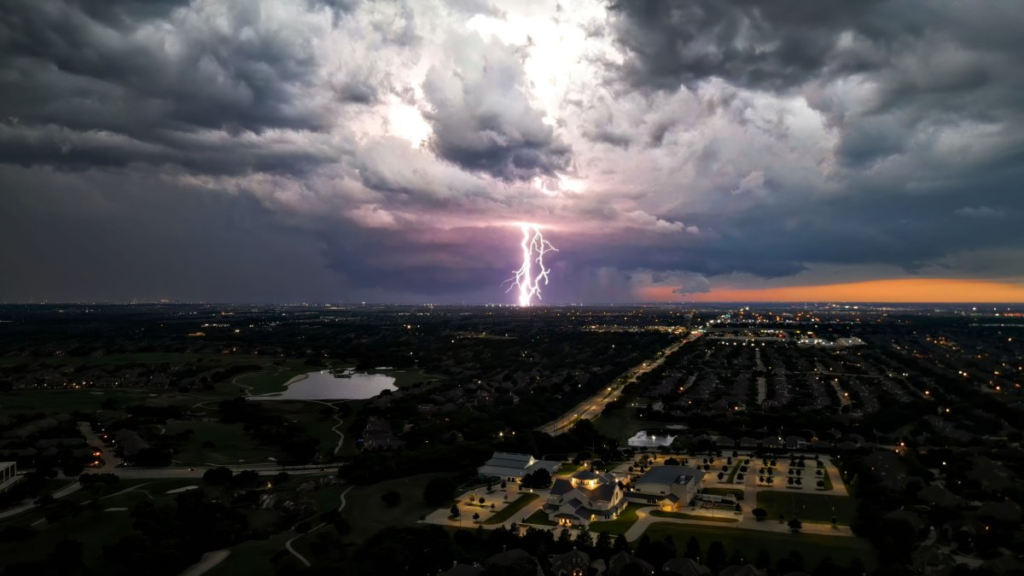
The National Weather Service (NWS) has issued a severe thunderstorm watch for most of North Texas, in effect until 10 p.m. Thursday. This alert includes major metropolitan areas such as Dallas, Fort Worth, Arlington, Plano, Denton, and surrounding counties.
Weather authorities are urging residents to stay alert and monitor updates as strong thunderstorms move through the region, bringing heavy rain, hail, and damaging winds.
Click here for real-time radar and updates from the National Weather Service
What the Severe Thunderstorm Watch Means
A severe thunderstorm watch is issued when weather conditions are favorable for the development of severe thunderstorms. These storms may include wind gusts above 58 mph, hail the size of quarters or larger, and frequent lightning.
As per NWS meteorologist Kevin Hobgood, “The current atmosphere across North Texas is unstable. Any storm that forms could quickly become severe and pose a threat to property and safety.”
Residents should prepare for rapidly changing weather and seek shelter if storms approach their area.
Areas Under Threat
The severe thunderstorm watch currently covers multiple counties, including:
- Dallas County
- Tarrant County
- Collin County
- Denton County
- Parker County
- Johnson County
- Ellis County
- Kaufman County
- Wise County
Communities in both urban and rural parts of the region could be impacted. Motorists, outdoor workers, and people attending evening events should be especially cautious.
You can view the latest county-by-county alerts here
Expected Storm Threats: High Winds, Hail, and Flash Flooding
The main threats associated with tonight’s storms are high winds and large hail, but meteorologists are also watching the potential for localized flash flooding.
Rainfall amounts are expected to range between 1 to 2 inches, with higher amounts in isolated areas. Low-lying roads and urban streets may flood quickly in a short period.
“Wind gusts may reach up to 70 mph in some storms,” Hobgood noted. “That’s enough to knock down tree limbs, damage roofs, and topple power lines.”
The NWS also warned of the possibility of hail up to 1.5 inches in diameter, which can damage cars and windows.
What to Do If You’re in the Watch Zone
If you’re in the affected areas, here are some steps to stay safe:
- Secure outdoor furniture and plants that could become projectiles in high wind
- Charge your phones and devices in case of power outages
- Avoid traveling during storms if possible; driving can be dangerous due to low visibility and flooded roads
- Download weather alert apps or tune into local news for real-time updates
To stay informed, check local weather advisories and follow emergency management officials on social media
No Tornado Risk Yet, But Still Be Prepared
As of now, no tornado warnings are in effect, but the possibility cannot be entirely ruled out. Conditions could evolve quickly in the evening, especially as temperatures drop and air pressure shifts.

“Tornado development is not the primary concern right now,” said Hobgood, “but as always with severe thunderstorms, there’s a non-zero chance.”
Residents are encouraged to keep shelter plans ready, especially those living in mobile homes or poorly constructed buildings.
Evening Events and Travel May Be Affected
Many residents in North Texas had plans for outdoor activities, sports events, or travel. Due to the late-night timing of the storm watch, officials recommend reconsidering or delaying evening outings.
Airports in the region, including DFW International and Dallas Love Field, may experience flight delays or cancellations. Travelers are advised to check with their airlines in advance.
Track airport conditions and airline updates here
Power Outages Likely in Some Areas
Due to wind speeds and the potential for falling limbs, localized power outages are likely, especially in older neighborhoods with overhead power lines.
Utility providers like Oncor Electric Delivery and CoServ are on high alert and ready to respond. Residents can report outages directly on their provider’s website or app.
Check Oncor’s outage map and report issues here
North Texas Residents Urged to Stay Weather-Aware
Emergency management teams across the region are on standby and will be issuing alerts as conditions change. Officials are asking the public to:
- Avoid rumors or unverified reports on social media
- Use NOAA weather radios if available
- Follow trusted sources like the NWS, local meteorologists, and city emergency departments
Follow the National Weather Service Fort Worth office on Twitter/X for up-to-the-minute information
Looking Ahead: When Will the Storms Move Out?
According to the NWS, most of the storm activity is expected to clear out of the region by midnight, although lingering showers could continue into the early hours of Friday.
By Friday morning, weather is forecast to improve, with clear skies and mild temperatures expected through the weekend.
Still, the agency warns that another storm system may develop early next week. North Texans are encouraged to continue watching forecasts and stay weather-aware.
Final Thoughts
As North Texas braces for another round of powerful weather, officials and meteorologists alike stress one message: Don’t take chances.
With winds, hail, and heavy rain likely, preparation and awareness are the best tools for safety. As the evening unfolds, continue monitoring alerts and act quickly if warnings escalate.
Stay indoors, stay connected, and stay safe.
For detailed storm updates and safety tips, visit the National Weather Service Dallas/Fort Worth official page.
Also Read – Massive Greer Fire Destroys 9,500 Acres in Apache County