
The Midwest and parts of the South are bracing for a powerful wave of severe storms that could bring tornadoes, damaging winds, large hail, and life-threatening flooding. The National Weather Service (NWS) has issued urgent warnings for millions of residents across states like Arkansas, Missouri, Tennessee, Kentucky, Illinois, and Indiana, as forecasters predict a multi-day weather event that could leave a lasting impact. With the potential for “generational” flooding and destructive tornadoes, communities are on high alert, and officials are urging residents to stay prepared. Here’s what you need to know about the severe weather threat hitting the Midwest in 2025.
A Dangerous Weather System Unfolds
A massive storm system is sweeping across the central United States, fueled by warm, moist air from the Gulf of Mexico colliding with cooler air from the north. This volatile combination is creating the perfect conditions for severe thunderstorms, capable of producing tornadoes, hail as large as baseballs, and torrential rainfall. According to the NWS, the storm system is expected to stall over the region, leading to prolonged heavy rain and increasing the risk of flash flooding in areas unaccustomed to such extreme conditions.
The storms began impacting the region earlier this week, with reports of at least 30 tornadoes touching down across states like Arkansas, Missouri, Tennessee, and Kentucky. In McNairy County, Tennessee, an EF-3 tornado with winds of 160 mph caused widespread destruction, damaging 332 buildings and claiming at least five lives. Similarly, in Lake City, Arkansas, homes were flattened, cars were tossed into trees, and entire neighborhoods were left in ruins. The NWS has described this as a “multi-day catastrophic and potentially historic” event, with severe weather risks continuing through the weekend.
Tornado Threats: A Growing Concern
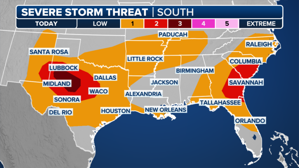
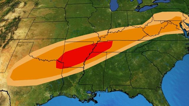
The Midwest and South are no strangers to tornadoes, but the intensity and frequency of these storms in 2025 have raised alarm bells. The NWS Storm Prediction Center has issued rare “high risk” alerts for parts of the Mississippi Valley, including cities like Memphis, Little Rock, and St. Louis. These alerts signal the potential for strong, long-track tornadoes capable of causing significant damage. In fact, nighttime tornadoes, which are nearly twice as likely to be deadly, are a particular concern as storms are expected to intensify after sunset.
On April 2, 2025, a tornado in Vernon County, Missouri, derailed eight train carriages and damaged homes and businesses. In western Kentucky, another tornado injured four people, while a confirmed EF-1 tornado caused chaos in the region. Forecasters warn that cities like Chicago, Indianapolis, and Nashville could see severe storms capable of producing tornadoes in the coming days. Residents are urged to stay weather-aware, have a safety plan, and identify a sturdy shelter, such as a basement or an interior room on the lowest floor of a building.
For real-time updates on tornado warnings, visit the National Weather Service website.
Flooding Risks: A “Generational” Threat
Perhaps the most alarming aspect of this storm system is the potential for catastrophic flooding. The NWS Weather Prediction Center has forecasted rainfall totals of up to 15 inches in parts of northeastern Arkansas, southeastern Missouri, western Kentucky, and southern Illinois through the weekend. This amount of rain, equivalent to several months’ worth in just a few days, could overwhelm rivers, streams, and drainage systems, leading to flash flooding in both rural and urban areas.
In Hopkinsville, Kentucky, floodwaters have already submerged downtown streets, forcing residents to use sandbags and pumps to protect their homes and businesses. In Falmouth, Kentucky, the rising Licking River has caused road closures and prompted voluntary evacuations. The NWS has warned that areas not typically prone to flooding could be at risk, with some locations potentially facing a “once-in-a-quarter-century” event. The Black River in Poplar Bluff, Missouri, is expected to crest near record levels, prompting the deployment of Missouri Task Force 1 with boats, drones, and search dogs to prepare for rescue operations.
AccuWeather has highlighted the catastrophic flood risk in states like Arkansas, Missouri, and Tennessee, urging residents to prepare emergency kits and avoid flooded roadways. For tips on flood preparedness, check out AccuWeather’s severe weather guide.
The Human Toll: Lives Lost and Communities Disrupted
The storms have already left a devastating mark on communities across the Midwest and South. At least 18 deaths have been reported since the storm system began, with 10 fatalities in Tennessee alone. Among the victims was a 9-year-old boy in Kentucky swept away by floodwaters while walking to his school bus stop, and a 5-year-old boy in Arkansas killed when a tree fell on his family’s home. In Missouri, a 16-year-old volunteer firefighter lost his life in a crash while attempting to rescue others during the storm.
Power outages have affected hundreds of thousands of households, with over 400,000 customers losing electricity across Arkansas, Missouri, Tennessee, and Kentucky at the storm’s peak. In Indiana, Governor Mike Braun declared a state of emergency, activating 50 National Guard members to assist with recovery efforts in 41 affected counties. The White House also approved Tennessee’s state of emergency request as floodwaters threatened Nashville and surrounding areas.
Despite the destruction, stories of resilience have emerged. In Selmer, Tennessee, Matt Vandevander survived a tornado that ripped him from his bathtub and threw him into a neighbor’s yard, escaping with only minor scratches. “It’s a miracle,” he told local media, a sentiment echoed by many who have witnessed the storms’ fury.
Climate Change and Severe Weather
Scientists point to climate change as a key factor intensifying these extreme weather events. Warmer air holds more moisture, leading to heavier rainfall and more severe flooding. A marine heatwave in the Gulf of Mexico is also contributing to the storms by providing a rich source of moisture. According to a recent analysis by Climate Central, heavy precipitation events are becoming more frequent across the U.S., with the Midwest and Ohio River Valley among the most affected regions.
While the link between climate change and tornado formation is less clear, the increasing severity of storms is undeniable. The 2024 tornado season saw over 1,855 tornadoes nationwide, and while 2025 is not expected to match that record, it could still be above average. Experts urge communities to stay vigilant and invest in long-term resilience measures to cope with these evolving weather patterns.
How to Stay Safe
With severe storms expected to continue, preparation is critical. Here are some practical steps to protect yourself and your loved ones:
- Stay Informed: Monitor local weather updates through trusted sources like the NWS or local news outlets. Download weather apps for real-time alerts.
- Prepare a Safety Plan: Identify a safe shelter in your home, such as a basement or an interior room away from windows. Practice tornado drills with your family.
- Avoid Flooded Areas: Never drive through flooded roads, as just 12 inches of water can sweep a car away. Follow the mantra: “Turn around, don’t drown.”
- Emergency Kit: Keep a kit with essentials like water, food, flashlights, batteries, and first-aid supplies ready in case of power outages or evacuations.
For detailed safety tips, visit the Federal Emergency Management Agency (FEMA) website.
What’s Next?
As the storm system moves eastward, forecasters are closely monitoring its path. By Sunday, the severe weather threat is expected to shift toward the Southeast, with Alabama, Georgia, and Florida potentially facing tornadoes and heavy rain. Meanwhile, recovery efforts are underway in hard-hit areas, with communities coming together to clear debris, restore power, and support those who have lost homes and loved ones.
The Midwest and South face a long road to recovery, but the resilience of these communities shines through. By staying informed and prepared, residents can navigate this dangerous weather event and emerge stronger. Stay safe, stay alert, and keep an eye on the skies as this historic storm system unfolds.
Sources: National Weather Service, AccuWeather, The New York Times
Must Read :- ScienceAlert.com Sees 66% Traffic Surge with Consumer-Focused Science News Stories