

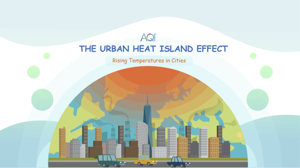
Urban heat islands are becoming an increasing concern as cities grow and global temperatures rise. These areas of elevated temperatures in urban environments affect public health, energy use, and overall comfort. Understanding how to map these high-risk zones and apply effective cooling strategies is essential for building healthier and more sustainable cities. This article explains what urban heat islands are, how they can be mapped, and which cooling interventions can help reduce their impact.
What Are Urban Heat Islands?
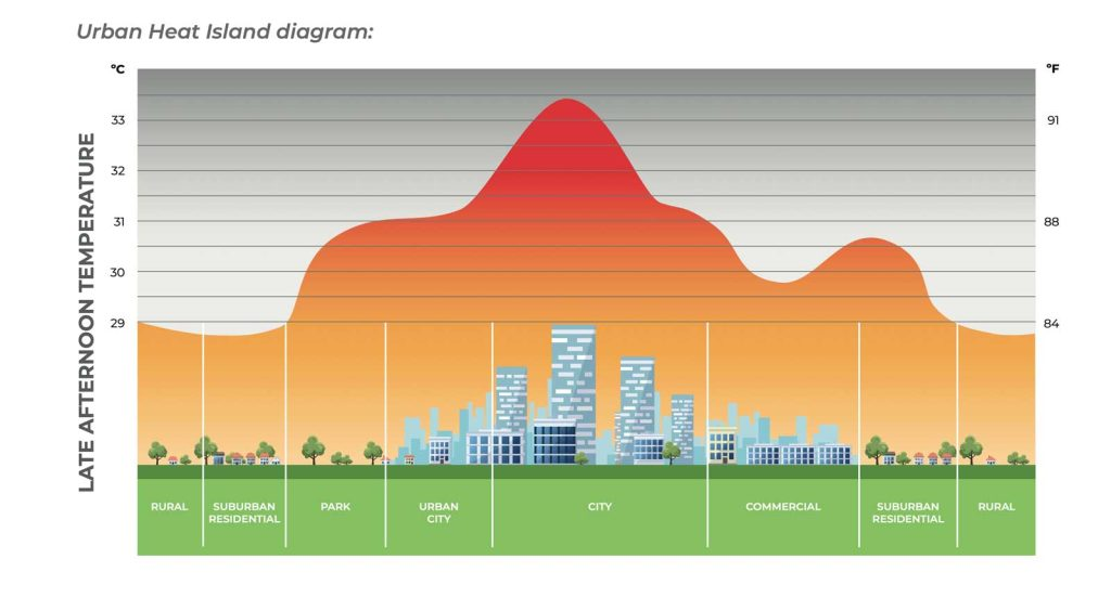
Urban heat islands occur when urban areas experience higher temperatures than surrounding rural regions. This happens because surfaces like buildings, roads, and parking lots absorb and store heat during the day and release it slowly at night. Limited vegetation, dense construction, and heat generated by vehicles and industry also contribute to this warming effect.
As a result, cities can be several degrees warmer, especially during hot seasons. The increased heat can lead to higher health risks, such as heat exhaustion and respiratory problems, increase energy demand for cooling, and worsen air quality.
Why Is Mapping Urban Heat Islands Important?
Mapping urban heat islands helps identify which parts of a city are most affected by extreme heat. This information is valuable because it allows city planners and officials to:
- Focus resources on vulnerable neighborhoods.
- Design targeted cooling interventions.
- Prepare for heat emergencies.
- Monitor changes over time to assess intervention success.
Using accurate maps also supports more equitable urban planning by ensuring cooling solutions reach the communities that need them most.
Methods for Mapping Urban Heat Islands
There are several ways to map urban heat islands:
Satellite Imaging
Satellites equipped with thermal sensors capture temperature data from space. These images show surface temperatures and can highlight heat hotspots across an entire city. They provide a broad overview but may lack fine detail.
Aerial and Drone Surveys
Drones and aircraft fitted with thermal cameras fly over cities to capture high-resolution temperature data. This method offers detailed and up-to-date information that complements satellite imagery.
Ground Sensors and Weather Stations
Cities often use fixed sensors and weather stations distributed throughout neighborhoods to measure temperature and humidity. These provide continuous, ground-level readings that reflect actual human exposure to heat.
Community Involvement
Some cities encourage residents to collect temperature data using smartphone apps or portable sensors. This crowdsourced information can help fill gaps and increase the accuracy of heat maps.
By combining data from these sources, urban heat maps can pinpoint areas with the greatest heat risk, often correlating with zones lacking green spaces or dominated by dark, heat-absorbing surfaces.
Characteristics of High-Risk Urban Heat Zones
Urban heat islands are not uniform. Some areas face greater risk due to specific factors:
- Dense urban centers with lots of concrete, asphalt, and tall buildings trap heat and limit airflow.
- Industrial districts generate additional heat from factories and machines.
- Neighborhoods with little to no vegetation have fewer natural cooling effects.
- Low-income communities often live in these hotter areas and may have less access to air conditioning and green spaces.
Identifying these characteristics helps prioritize where cooling efforts can have the most significant impact.
Cooling Interventions to Combat Urban Heat Islands
After mapping the hot zones, cities can apply several strategies to reduce temperatures and improve comfort:
Increasing Urban Greenery
Planting trees, creating parks, and installing green roofs provide shade and cool the air through evapotranspiration. Trees alone can reduce local temperatures by several degrees, making streets and outdoor spaces more comfortable.
Cool Roofs and Pavements
These use reflective materials that bounce sunlight away instead of absorbing it. Cool roofs keep buildings cooler and reduce energy use for air conditioning. Reflective pavements lower surface heat and help cool surrounding air.
Urban Water Features
Water bodies like fountains, ponds, and misting stations cool air through evaporation. They absorb heat during the day and release it more slowly at night, moderating temperature extremes.
Improved Building Design
Designing buildings to maximize airflow, increase spacing, and provide shading can reduce heat buildup. Features such as awnings, pergolas, and ventilated facades help keep interiors cooler.
Reducing Waste Heat
Using energy-efficient appliances, cleaner transport, and better industrial processes reduces the amount of heat released into the environment.
Examples of Cooling Programs in Cities
Many cities worldwide have launched initiatives to combat urban heat islands with success.
New York City mapped its heat hotspots and planted thousands of trees in vulnerable neighborhoods. The city also promotes cool roofs and reflective pavements to reduce temperatures.
Melbourne in Australia is working to increase tree canopy coverage from 22% to 40% over the next few decades to improve livability amid rising temperatures.
Singapore integrates greenery extensively into urban design with green roofs, vertical gardens, and water features in its dense cityscape.
Challenges in Tackling Urban Heat Islands
Despite many benefits, cities face challenges when addressing urban heat islands:
- Funding and resource constraints limit how much green infrastructure and retrofitting can be done.
- Limited space in dense urban areas makes planting trees or adding parks difficult.
- Maintaining green spaces requires ongoing effort, including watering and pruning.
- Cooling efforts may not always reach vulnerable or low-income communities without targeted planning.
- Climate change causes more frequent and intense heatwaves, increasing the urgency and complexity of solutions.
The Role of Communities and Technology
Community involvement plays a key role in the success of cooling interventions. Residents can participate in tree planting, local temperature monitoring, and advocating for resources.
Technology continues to improve the ability to detect, map, and reduce urban heat islands. Smart sensors provide real-time data, and artificial intelligence helps analyze heat patterns and predict risks. Innovative materials and architectural designs also contribute to more effective cooling.
Conclusion
Urban heat islands are a major challenge for growing cities in a warming world. Mapping these high-risk zones helps identify where cooling interventions are most needed. By increasing urban greenery, using cool materials, improving building design, and reducing waste heat, cities can become cooler and healthier places to live.
Though challenges remain, combining technology, community action, and smart planning offers a path forward. As more cities adopt these strategies, we can expect urban environments that better withstand heat, protect vulnerable populations, and improve quality of life for everyone.
Do Follow USA Glory On Instagram
Read Next – Urban Ecotherapy Mental Health: Efficacy, Access & Policy Changes