

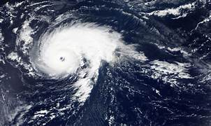
Hurricane Erin weakens to Category 3 after previously being stronger. Although the downgrade eases fears of catastrophic winds, it still packs sustained wind speeds between 111–129 mph (178–208 km/h), remaining a major hurricane. The National Hurricane Center (NHC) reports that Erin’s eye has grown larger and wall clouds are becoming less defined—classic signs of gradual weakening.
However, Erin’s central pressure remains low, tightly packed bands of rain and gusty winds are lashing coastlines, and its forward motion is slow—meaning prolonged exposure for those in Erin’s path. Metaphorically, think of it as a fierce lion standing still: not as deadly as before, but more dangerous the longer you’re near.
What a Category 3 Storm Means
A Category 3 hurricane is defined by sustained winds of 111–129 mph. Dangers include:
- Major damage to homes, buildings, and infrastructure
- Uprooted trees, downed power lines, and widespread power outages
- Torn-off roofs and destroyed mobile homes
- Risk of roof failure or structural collapse on poorly fortified buildings
- Heavy rain leading to flash flooding and mudslides
Even with weakening, Erin still meets this threshold and must be taken seriously by all in affected areas.
Areas Most at Risk
- Coastal zones – storm surge may rise between 9–12 feet (2.7–3.7 meters), flooding low-lying roads and buildings.
- Inland regions – heavy rain remains a major hazard, especially where the storm stalls.
- River valleys and hillsides – risk of mudslides and rapid river flooding increases dramatically.
Forecasts show the storm approaching the coastline in the next 48 hours, with heavy impacts still expected.
What to Expect: Wind, Rain, Surge
Wind
Though slightly reduced, gusts may still exceed 120 mph. These can:
- Bring down tree limbs and entire trees
- Damage roofs and siding
- Blow debris at dangerous speeds
Rain
Heavy rainfall—up to 10–15 inches in some areas—may cause:
- Flash flooding
- Urban inundation
- Overflowing creeks and small rivers
Storm Surge
Even at Category 3 strength, surge levels of 9–12 feet can:
- Flood coastal neighborhoods
- Submerge ground floors
- Knock out dunes and coastal defenses
Safety Precautions & Emergency Plans
Hurricane Erin weakens, but complacency is dangerous. Follow these steps:
Evacuate When Advised
If local authorities issue orders:
- Follow evacuation routes
- Head to designated shelters or safer ground
- Have a “go bag” ready with essentials
Secure Your Home
- Board up or reinforce windows and doors
- Anchor outdoor items (e.g. patio furniture, trash bins)
- Trim dead branches near structures
Have Emergency Supplies
- Water: At least 1 gallon per person, per day, for 3–7 days
- Non-perishable food, flashlight, batteries, first-aid kit
- Backup power sources (batteries, power banks)
- Medications, pet supplies, important documents in waterproof packaging
Stay Informed
- Tune into NOAA Weather Radio or local stations
- Monitor official alerts (via smartphone or emergency apps)
- Don’t depend on social media—use verified updates only
Preparation Steps for Communities and Individuals
| Preparing for Hurricane Erin | What You Should Do |
|---|---|
| At Home | Reinforce doors and windows, clear gutters, stock supplies |
| While Evacuating | Keep gas tank full, know your route, stay alert to changes |
| For Pets & Special Needs | Bring meds, ID tags, crates, mobility aids, service animal gear |
| Community Support | Check on neighbors, help elderly or vulnerable individuals |
| After the Storm | Avoid standing water, inspect damage safely, contact local aid |
Responding to Evolving Storm Conditions
Conditions may shift rapidly. Erin may:
- Slow further or stall, increasing rainfall duration
- Drift slightly inland or shift direction, altering impact zone
- Continue weakening into Category 2—but other risks persist
If tracks change, local evacuation zones may need adjustment, so remain alert. If winds drop below 111 mph, Erin may be reclassified, but flooding, surge, and debris still pose serious threats. Always plan for the worst, hope for the best.
Frequently Asked Questions (FAQ)
Q: If Hurricane Erin weakens to Category 2, is it safe to stay at home?
A: No—Category 2 still brings intense wind, rain, and flood hazards. Only evacuate when authorities say it’s safe or mandatory.
Q: Will insurers cover flood damage?
A: Not always. Flood insurance is usually separate. Review your policy now—do not wait until Erin hits.
Q: How long does flooding last after the storm passes?
A: Floodwaters may persist days after the storm, especially in low-lying or poor-drainage areas.
Q: Should I turn off my electricity manually?
A: Only do so if instructed by local authorities. Improper action may risk damaging appliances or cause danger.
Final Thoughts
Yes, Hurricane Erin weakens, but it remains a serious threat. A Category 3 hurricane still has the power to destroy, flood, and topple. Your safety—or that of loved ones—depends on preparation, clear action, and staying informed.
✔ Before the storm: Gather supplies, secure your space, know evacuation routes
✔ During the storm: Stay indoors, away from windows, follow official updates
✔ After the storm: Wait for “all clear,” check for hazards, reach out for help if needed
Together, with smart preparation and caution, we can weather the storm. Stay safe.
Also Read : Why Space Tourism Might Be Closer Than You Think