

A powerful nor’easter is currently sweeping across the United States, bringing heavy snowfall, icy conditions, and dangerously low temperatures to multiple regions. Originating in the central Plains, the storm has intensified, affecting areas from the Midwest to the mid-Atlantic, with some regions experiencing near-record snowfall and frigid temperatures.
Central United States Faces Hazardous Conditions
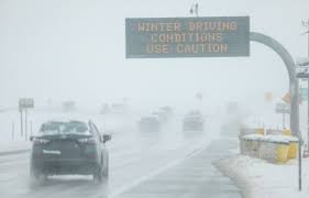
The central U.S. has been particularly hard-hit by the storm. In Oklahoma, treacherous icy roads led to numerous accidents, including a notable incident on the Will Rogers Turnpike. A semi-truck transporting eggs lost control due to the slick conditions, resulting in a massive spill that covered the highway. Fortunately, only minor injuries were reported, but the incident highlights the severe impact of the storm on transportation and supply chains.
Texas is also grappling with the storm’s effects. The state is experiencing a significant arctic blast, with temperatures plummeting across various regions. The Texas Panhandle has already witnessed snow and subzero temperatures, while West Texas is under an extreme cold warning. Central areas, including San Angelo, are enduring sustained freezing temperatures expected to last until Thursday afternoon, with a gradual warming trend anticipated by the weekend. North Texas, particularly the Dallas-Fort Worth area, is under a winter weather advisory due to potential freezing rain, and South Central Texas, including San Antonio, is on high alert for extreme cold, prompting residents to take precautions against hypothermia and frostbite.
Mid-Atlantic and Northeastern States Brace for Impact
As the nor’easter progresses eastward, the mid-Atlantic and northeastern states are preparing for its arrival. Forecasts indicate that areas from eastern Kansas to Missouri, extending to eastern Virginia, including Norfolk, could experience up to 12 inches of snow. While New York City is expected to see a wintry mix starting Wednesday night into Thursday morning, snowfall accumulation is projected to be less than an inch. By Thursday afternoon, only flurries are anticipated to remain. The most significant impacts are expected south of Washington, D.C., sparing much of the East Coast from earlier predictions of heavy snowfall. However, forecasters caution that the storm’s track and snow accumulations could change before the system dissipates later in the week.
Record-Breaking Cold Temperatures Expected
In addition to heavy snowfall, the nor’easter is ushering in a severe burst of Arctic air, marking the 10th polar vortex invasion this winter. This event is set to plunge the U.S. into its coldest temperatures yet, extending into next week. The phenomenon, caused by weather patterns in the Arctic, will significantly freeze parts of the country, excluding only central and southern Florida and the far West. Temperatures are expected to drop drastically, with projected lows of 16.6°F on Tuesday, further chilling to 14°F by Wednesday. Approximately 89% of the contiguous U.S. is anticipated to experience below-freezing temperatures. Strong winds will exacerbate the cold conditions, leading to dangerous wind chills.
Understanding Nor’easters
A nor’easter is a storm along the East Coast of North America, so named because the winds over the coastal area are typically from the northeast. These storms can occur at any time of year but are most frequent and severe between September and April. Nor’easters are known for bringing heavy precipitation, strong winds, and coastal flooding, often resulting in significant disruptions to daily life.
Safety Precautions and Preparedness
Authorities across the affected regions are urging residents to take necessary precautions to ensure their safety. Travel is strongly discouraged due to hazardous road conditions, and those who must travel are advised to carry emergency kits, including blankets, food, and water. Residents are also encouraged to check on vulnerable neighbors and family members, ensure pets are protected from the cold, and take steps to prevent pipes from freezing.
As the situation continues to evolve, staying informed through local news and weather updates is crucial. The National Weather Service and local authorities will provide ongoing information regarding the storm’s progression and any necessary emergency measures.
Conclusion
The current nor’easter is a stark reminder of the power and unpredictability of winter storms. With its wide-reaching impact, from heavy snowfall and icy roads to record-breaking cold temperatures, it underscores the importance of preparedness and caution during such events. As communities across the United States navigate the challenges posed by this storm, collective efforts and adherence to safety guidelines will be essential in mitigating its effects.
More Updates : USA Glory.